• There has been a recent cluster of spammers accessing BARFer accounts and posting spam. To safeguard your account, please consider changing your password. It would be even better to take the additional step of enabling 2 Factor Authentication (2FA) on your BARF account. Read more here.

Mount Patterson Hot Spring Campaign ...

Joined
Nov 30, 2010
Location
San Francisco, 94102
Moto(s)
KLR, K75s, TR7V, FXSB
Name
John A.
BARF perks
AMA #2917550
Hey BARF Adventure Riders,

A low-mileage KLR recently found its way into my garage,
thanks to leesagi, who sold me his 2005 bike a couple of months ago ...

20140830-003935.jpg


Set it up with new Dirt Bagz, new 606s, new chain, new sprocket and
new 14t front sprocket, a old bash plate and a tune-up ...

Ready to head out and bond with it! :ride

20140829-094700.jpg


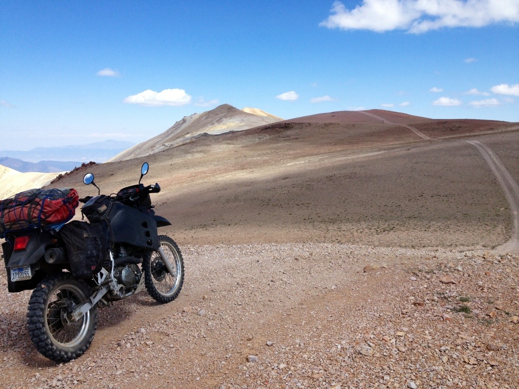
Been trying to ride up and over Mt Patterson for years ... gave up
my first attempt, shocked at how much more difficult the
riding is in truly big mountains, compared to the Sheetiron's easy splits
in the Mendo NF, ha. :nchantr

Anyway, here's a SPOT map of the three night solo trip this week ... Sonora Pass,
East Walker River Hot Springs, Risue Road, Monitor Pass and Ebbetts Pass ...
 
Last edited:
Sonora Pass ...

I rolled out of Lower Haight at 1pm on Monday, off like a heard of turtles ...

Took Hwy 108 and was soon heading over Sonora Pass ...

20140830-004001.jpg


Figured I'd find a view and set up camp on one of the many
dirt roads just to the northeast of the pass ...

20140830-004054.jpg


Found an epic view to the east ...

20140830-004142.jpg


Set up camp ...

20140825-193213.jpg


The road to the view ...

20140825-193308.jpg


Watched the sky ...

20140829-002701.jpg


And watched the sunrise over Mt Patterson the next morning ...

Which was the start of a beautiful day ... I drank coffee and read
my book in a hammock ... Soon it was 11am ... maybe I'd skip Mt Patterson ...
by myself, new bike, tough ride I'd never done before,
with a fat load of camping gear ...

Loafing around and taking in the view in the sunshine all day
was pretty appealing ...
 
Last edited:
Oh well, may as well load up the bike and at least take a look
at the western approach to Mt Patterson ... could always
simply turn around if it got too scary, right?

20140829-003002.jpg


A view to the west up from Bircham Flat, on the way to
Lobdell Lake ...

20140829-003816.jpg


After a steep gnarly climb we were above the tree line ... always kind of
forget how turning back seems less of an
option after a tough climb. Double ha. :rolleyes

20140829-001537.jpg


Like my friend Ryan says, to get to the top "you got to really want it ..."

Wasn't really feelin' it ... didn't really want to turn around ...
 
Last edited:
WOW....so cool!!!!! Thanks for the inspiration to do similar rides!!!!
 
WOW....so cool!!!!! Thanks for the inspiration to do similar rides!!!!

Hey MtnRider,

You're welcome, the area around Sonora and Ebbetts Passes
is reasonably close and so beautiful ... :ride

see you around the campfire,
-- SFMCjohn
 
20140829-003940.jpg


Soon enough I found myself at the summit, that I'd see so often in
pics on-line ...

20140829-005339.jpg


A view of the road onward ... needed to decide if I should continue on,
or head back the way I just came up ...

20140829-005508.jpg


The weather was so nice I could take off my jacket and
enjoy a cup of coffee by the flag ... there were a ton of
falcons chasing picas or mice in the vast scree fields ...

20140829-005747.jpg


Looking northeast ... Hwy 338, Sweetwater Summit and Risue Road
heading west just to the north of the Three Sisters ...

20140829-005821.jpg


Looking west at Lucky Boy Pass and Mt Grant ...

20140829-010016.jpg


I decide to soldier on ... looking back up the road that heads east from the summit ...

20140829-010217.jpg


It heads around the flank of 11,600 foot Walker Peak, before plunging
down to the old ghost town of Belfort ...

20140829-010332.jpg


Getting ready to head back below tree-line ...
 
Last edited:
Finally wore that old KLR out, eh? :laughing

Didja make it over the mountain?

Hey NB!

Haha, I could not believe what a bucket that ol' Barbie seems
like after riding the low-mileage example ... :laughing

The frame on the Barbie was starting to crack ...
guess she didn't owe me anything ... :party

So, I'm over the top ... We'll see whether I can get down ...
The section just below Belfort is notoriously difficult ...
I took one look at it heading up years ago, and just
turned around ... :|

best to T!
-- SFMCjohn
 
Wow awesome I'll have to try this on the DR sometime unfortunately I will will be heading the opposite direction going to Death Valley.

You KLR riders, they're so big and heavy I don't know how you guys do it. I don't feel comfortable in the dirt on my KLR at all. Looks like yours is seriously outfitted for some rough times.
 
I have a bash plate and I'm gonna use it!

Wow awesome I'll have to try this on the DR
sometime unfortunately I will will be heading the opposite direction going
to Death Valley.

You KLR riders, they're so big and heavy I don't know how you guys do it.
I don't feel comfortable in the dirt on my KLR at all.
Looks like yours is seriously outfitted for some rough times.

Hi HO,

Your DR would love Mt Patterson, and DV was a good way for me
to get experience riding on steep, rocky, loose, rutted roads ... :thumbup

Maybe someday I'll get a DR or DRZ. I imagine on a lighter bike I'll
think I've died and gone to heaven ... :laughing

This picture looks like a painting.

That's some beautiful country you were riding in, did you see anybody else while you were up there or did you have the ridge line to yourself?

Hi Saltwater,

It's such a neat area to be able to ride a bike that it was pretty easy
to snap some pics I was happy with on my little i-phone ...

I was up there on a Tuesday and had it all to myself ... From what I understand, it's a pretty popular quad and jeep destination on weekends ...

Subscribed! Tell me more :thumbup

Hi Tydive,

Here we go, back to it! :party
 
20140829-003314.jpg


Thought this sign was interesting ...

Like Clear Creek, Mt Patterson was extensively mined, and has old
mining roads, shafts, buildings and tailings all over it ...

So, yes, intensive mining activity probably permanently changes
a landscape ... hopefully that will exclude the area from ever
being designated a wilderness, ha. :rolleyes

Still very beautiful ...
 
Belfort ...

20140829-083347.jpg


Belfort is a ghost town at 10,000 feet on the flank of Walker Peak … They mined for silver and gold in the 1880s …

20140829-083510.jpg


20140829-083534.jpg


The place was re-discovered by a hunter in the 1930s, with many of its
artifacts still intact … you can see some of them at the county
history museum in Bridgeport …

20140829-083847.jpg


Belfort’s remote location and difficult jeep-trail protect it …
I poked around a bit before rolling on …
The road just below Belfort was the section that turned me back years ago …

20140829-084355.jpg


Challenging KLR riding, ha. Steep, narrow, loose and rocky …
a bit of deep sand was my undoing here …
had to unload the bike a bit to pick it up, but was soon on my way to Star City,
a mining community that is gone now,
where I’d turned around in 2010 …

I'll always be a n00b, but I was interested to see what this
section below Belfort looked like to me now, thinking that
I'd be disappointed in myself for having turned back in 2010 ...
wound up being proud of myself for having good sense! :laughing
Don't think I could ride up this section with a loaded KLR ... :ride
 
Throwing myself down the trail to the Hotsprings ...

Eventually I popped out onto Nevada Hwy 338 at Atchitson Road,
just north of the turn off for Lucky Boy Pass at the
big Sweetwater Ranch sign ...

The plan was to take Lucky Boy Pass Road and
go on past The Elbow and continue to search for the
hot spring on the East Walker River ...
I had explored a bunch of the little dirt jeep
Trails on the east side of the river over the years,
Trying to find this hot spring, without success ...

20140829-090028.jpg


... and I continued to bond with the new bike by throwing
it down the trail ... :laughing This one hurt a bit ...
I was trying to scoot down along on the smooth edge of the road
on the left side of the pic by giving it throttle ... call this a crash,
rather than my usual KLR tip-over ... Broke the rear brake pedal, ouch! :nchantr

Got the bike picked up. The silver lining to how steep the decent to
the river is here is that I didn't have to unload the bike to get it upright.
The black cloud was that I wasn't sure I'd be able to ride back up, ha. :rolleyes
There have been some gully washers out there this summer and
Trail 765K was in rough shape ...

The sun was going to set soon, and I'd already tried getting
to the hot spring down 765H (or 765E, 765F or 765G ... whatever) and been turned back by the
deep water crossing at Rough Creek and the East Walker River,
and I wasn't even sure I'd find the stupid hot spring down this trail ...

Finally made it to the river without my rear brake, and didn't see any
spring ... figgured I'd just head back and find a place to camp
along the bank, because it was going to get dark soon when
I saw it ...

20140829-091521.jpg


I'd ridden right past it ... turns out the road is so blown-out that the
hot spring isn't getting much use this season and the green plants
from the run-off around the spring have run riot ...

20140829-091141.jpg


20140829-091212.jpg


20140829-092520.jpg


I was pretty happy to have finally found it ... set up camp
and soaked my old bones ... There was no moon, so I watched
the Milky Way and the Big Dipper slowly reel counter-clockwise
around the North Star ... bliss ... :ride

20140829-091608.jpg


Looking back at camp from the East Walker River ...

I'd worry about riding back out in the morning ...
 
Last edited:
Leviathan Peak ...

In the event, after a night of rest and lots of coffee in the morning,
I managed to scoot up and out of the hot spring no problem ...

20140829-092722.jpg


20140829-093016.jpg


20140829-093129.jpg


View along 765K on the way out in the morning ...

20140829-093216.jpg


The road to the hot spring is actually pretty well marked
with these carsonite markers ... 765K is your friend ...

20140829-093355.jpg


Mount Patterson from the east, looking west ...

20140829-093724.jpg


The water crossing at the old stone ranch house on Lucky Boy Pass Road ...

I took Risue Road to get back to 395 and Monitor Pass ...

20140901-102821.jpg


... and rode up to the watch tower on Leviathan Peak ...

The Cowboy Breakfast was waiting for me in Markleeville at my
favorite coffee shop ... :ride
 
Great stuff, John!!!!! Love the pics, and the descriptions are fantastic as well. I have been through those passes, but have never really explored the dirt roads/fire trails/etc. in that area. Thanks for taking us all along on your ride. I REALLY need to take the KTM up there some time soon. Drop me a line if you want to go back :thumbup
 
John, Awesome solo ride man! You are insane!!!

How were the flies at Leviathan Peak? I was up there in my FJ last month and the flies were swarming so bad they were in our hair and ears, and a ton of them got inside the FJ.. It was nasty! The views up there are incredible though.

Thanks for taking time to post this one. I now have more places to add to my list to get out to...
 
Sweeet!
and just in time for Hawthorne....hmmmm...mebbe I should take the DR again :)
 
Back
Top