-
There has been a recent cluster of spammers accessing BARFer accounts and posting spam. To safeguard your account, please consider changing your password. It would be even better to take the additional step of enabling 2 Factor Authentication (2FA) on your BARF account. Read more here.
You are using an out of date browser. It may not display this or other websites correctly.
You should upgrade or use an alternative browser.
You should upgrade or use an alternative browser.
Glory this year??
- Thread starter CDONA
- Start date

berth
Well-known member
What, no daredevil kayakers?
CDONA
Home of Vortex tuning
- Joined
- Jul 30, 2010
- Moto(s)
- TW200, Monkey
- Name
- # 44659
The skateboarders run the "tube" during the summer, , ,

dravnx
Well-known member
- Joined
- Dec 13, 2012
- Location
- santa rosa, ca
- Moto(s)
- Kawi 1400GTR '12
R1200RS '18
- Name
- Jeff
- BARF perks
- AMA #3018349
Is that 150’ agl or msl? Unless your drone has a terrain database then it is reporting msl.
Lake Berryessa is at 443’ msl so your drone was at approx 100’ above the hole.
Above ground level
Mean sea level
Lake Berryessa is at 443’ msl so your drone was at approx 100’ above the hole.
Above ground level
Mean sea level
900ss
Well-known member
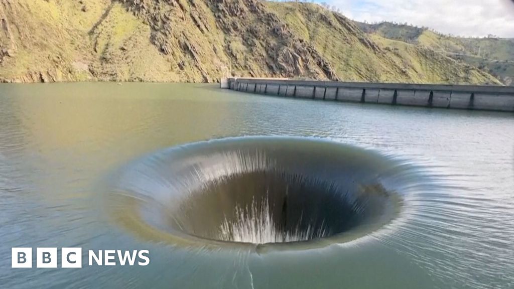
Plughole-like dam creates mesmerising water display
The Monticello Dam spillway in California was turned on for the first time since 2019 due to high water levels.
 www.bbc.com
- Joined
- Apr 4, 2002
- Location
- Menlo Park, Ca.
- Moto(s)
- Keep me rocking life
- Name
- Budman
- BARF perks
- AMA Life Member #203453
With the forcast coming later this week glory gonna be busy.
CDONA
Home of Vortex tuning
- Joined
- Jul 30, 2010
- Moto(s)
- TW200, Monkey
- Name
- # 44659
I'm gonna be looking for muddy bikes next week, I even have a chance for myself, this time, , ,

CDONA
Home of Vortex tuning
- Joined
- Jul 30, 2010
- Moto(s)
- TW200, Monkey
- Name
- # 44659
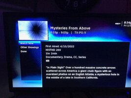
I caught an episode on tv last nite, starts out arial view of a lake, that I identify as to "looking like Berryessa"
and, it was. Something about sat. pix of a hole in the water.
So, if you want to know the history of the lake, what happened to Monticello, and why.
When they designed it, they expected it to fill to overflow, once in 50 years.
fun stuff,
and, it was. Something about sat. pix of a hole in the water.
So, if you want to know the history of the lake, what happened to Monticello, and why.
When they designed it, they expected it to fill to overflow, once in 50 years.
fun stuff,
Attachments
CDONA
Home of Vortex tuning
- Joined
- Jul 30, 2010
- Moto(s)
- TW200, Monkey
- Name
- # 44659
Lake Berryessa News
(4/20/26)
Lake Berryessa Statistics (4/20/26)
Lake Berryessa water level has risen about an inch to 438.8 feet - 1.2 feet below Glory Hole.
and,
Just because this is dated 4/20, The REAL history of it, , ,
 420waldos.com
(4/20/26)
Lake Berryessa Statistics (4/20/26)
Lake Berryessa water level has risen about an inch to 438.8 feet - 1.2 feet below Glory Hole.
and,
Just because this is dated 4/20, The REAL history of it, , ,
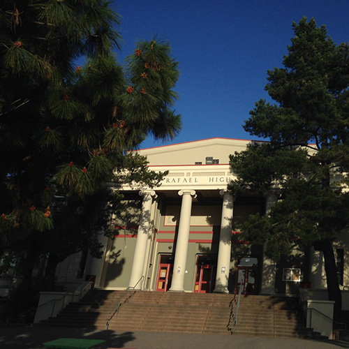
Home - 420 Waldos
Welcome to 420Waldos Website a group of five wisecracking friends from Marin County, California who originated the term '420' in 1971 at San Rafael High
420waldos.com
berth
Well-known member
As I understand it, in Colorado, I guess on the I80(?), they have a 419.9 mile marker sign, because the 420 sign was constantly being stolen.Just because this is dated 4/20, The REAL history of it, , ,
CDONA
Home of Vortex tuning
- Joined
- Jul 30, 2010
- Moto(s)
- TW200, Monkey
- Name
- # 44659
I've heard about the signs getting snagged, didn't know about the fix.
There was another "thing" about the old Az. SR 666 signs too.
There was another "thing" about the old Az. SR 666 signs too.
BillSmith
The Little Twitches Grandpa
- Joined
- Nov 22, 2007
- Moto(s)
- HD 2011 FXDF Dyna Fat Bob
- Name
- Bill
Two street signs in my little community, Pennyroyal and Shooting Star. Guess which has been stolen twice in the nine years we've live here.